| National Factbook |
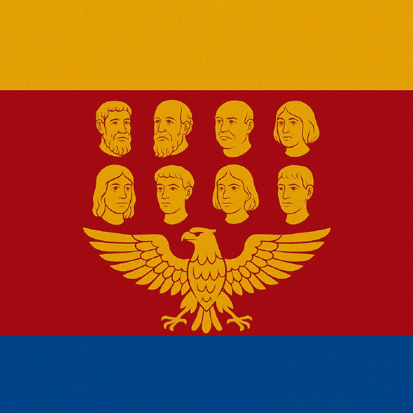
| Flag: |

|
| Nation Name: |
Acht Komaune |
| Leader Name: |
Hainrik Kolp |
| Currency: |

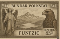
Tirn |
| National Animal: |

Golden eagle |
| History: |
🛡️🏔️ Mythical and Heraldic History of the Eight Communes
In time immemorial, when the world was still half-shrouded in mist and the highlands had no name, the Eight Peaks rose like watchful sentinels over the lowlands. From their craggy heights, eight guardian clans emerged — each said to be descended from a divine beast of the mountain winds: the Stag of the North, the Bear of the Stonewood, the Golden Eagle of the Skies, the Wolf of the Shadowed Pines, the Lynx of the Glacial Hollow, the Owl of the Silent Cliffs, the Ibex of the Sunlit Ridge, and the Fox of the Misty Vale.
Each of these lineages bore a sigil, an ancestral crest, and a sacred mountain oath: to protect the land, share the waters, and never raise steel against one another. This pact became the Oath of Hoaga, the sacred foundation of what would become the Hòoge Vüüronge dar Acht Komàüne — a sovereign brotherhood of mountainfolk united not by empire, but by blood, stone, and wind.
⸻
🕯️ The Founding Era
In the Third Era of the Crescent Star, as lowland kings warred over fields and gold, the eight clans gathered at the frozen Lake Vurscha and swore allegiance to a neutral council: the Hoaga Ebene — a rotating Regency composed of elders, warriors, and mystics from each commune. From this day forward, no single lord would rule the Highlands; instead, the land itself would govern through the voices of its guardians.
⸻
🏰 The Age of Forts and Fire
During the wars of the Southern Marches, the Eight Communes remained untouched, shielded by towering citadels, fogbound valleys, and a people trained in silent warfare and highland diplomacy. The Guldarn Agla (Golden Eagle) was adopted as the Federal Sigil — a symbol of vigilance and ascendance — while each commune maintained its own heraldic beast and banner.
The capital, built around the sacred rock of Hoagstein, became both a seat of law and a place of pilgrimage. It is said the Tri-Crowned Angel that stands above the capital — a colossal statue with three serene faces — represents the ancient spirits of wisdom, justice, and memory.
⸻
⚖️ Modern Age of the Free Peaks
Today, the Hòoge Vüüronge dar Acht Komàüne is a federal republic of mountains, where tradition and autonomy are upheld through a Great Charter, written in a mix of Old Cimbrian and High Alpic. The government is structured as a Regency Council, presided over by the First among Equals (Ersthoaga), while each commune retains full authority over local matters — including the guarding of sacred groves, lakes, and ancestral paths.
The national motto, “Im Hoagkeit unt Troit z’ammen“ (Pride and Loyalty, together) embodies the deepest meaning of the national values. |
| Geography |
| Continent: |
Europe |
| Land Area: |
5,069.42 sq. km |
| Terrain: |
The Hòoge Vüüronge dar Acht Komàüne lies upon a vast, uneven high plateau, surrounded by steep mountain ranges that naturally mark the borders with the outside world. Elevation varies between 1,200 and 2,600 meters, featuring deep valleys, forested ridges, and rugged peaks often veiled in mist.
The landscape is dominated by ancient coniferous forests, alpine meadows, and glacial lakes nestled on the lower slopes. Hidden caves and narrow crevasses are considered sacred sites, often protected by ancient legends. At the heart of the Regency rises Mount Bravenhorn, the most revered peak, said to be the source of the primordial stag’s spirit.
The eight communal regions are arranged around hills, lakes, and highlands, each with its own morphology and resources: some with fertile soil, others with high-altitude pastures, and some rich in hard stone ideal for carving and construction. |
| Highest Peak: |
Fiorotz,
2,636 meters
|
| Lowest Valley: |
Lares,
-1,011 meters
|
| Climate: |
The Hòoge Vüüronge dar Acht Komàüne experiences a rigorous alpine climate, deeply influenced by its mountainous geography and elevated terrain. Precipitation is frequent throughout the year, with snowfall dominating the long winters, especially from November to April. The region’s unique sky view factor—caused by open skies and reflective snow surfaces—contributes to extreme nighttime cooling, with winter temperatures occasionally plunging to -49°C, particularly in deep valleys and high-altitude basins.
Summers are short, cool, and clean, marked by refreshing breezes from glacial lakes and frequent afternoon storms. While temperatures rarely rise above 23°C, the region enjoys long daylight hours and vibrant alpine flora during this season.
Due to its rugged topography, the republic is home to a variety of microclimates, ranging from humid wooded slopes to dry, wind-swept ridges. These variations shape the identity of each commune, reinforcing local traditions, architecture, and seasonal rhythms.
|
| People & Society |
| Population: |
438,331 people |
| Demonym: |
Zimbar |
| Demonym Plural: |
Zimbarn |
| Ethnic Groups: |
Archaic Cimbrian - 73.0%
Troitscher - 10.0%
Felgauer - 6.0% |
| Languages: |
- 0.0% |
| Religions: |
- 0.0% |
| Health |
| Life Expectancy: |
83 years |
| Obesity: |
7.2% |
| Alcohol Users: |
33.1% |
| Tobacco Users: |
12.5% |
| Cannabis Users: |
4.3% |
| Hard Drug Users: |
0.2% |
| Economy |
| Description: |
The economy of the Regency is community-based, rooted in self-sufficiency and the preservation of ancestral knowledge. It relies primarily on:
• 🐐 Alpine herding: goats, sheep, and especially semi-domesticated deer, which serve both as a symbol and vital resource;
• 🌾 Mountain agriculture: hardy grains (rye, barley), root vegetables, and medicinal herbs grown on terraces;
• 🪵 Forestry and timber: sustainable woodland management and refined woodwork are essential trades;
• 🪨 Stonework and craftsmanship: the region is famed for its white and grey stone quarries, used for sculpture, arches, and tools;
• 🧶 Textile weaving: especially in the Troitscher commune, where ritual-patterned fabrics are produced;
• 🛖 Ceremonial trade and seasonal fairs: internal commerce revolves around ritual festivals where goods, animals, relics, salt, and metals are exchanged.
Trade with the outside world is rare, tightly regulated, and approached with caution. Only salt, metal tools, books, and pigments are imported by trusted caravans allowed to enter.
The economy is governed by communal councils, which set production rhythms in harmony with ritual calendars and collective needs. The official currency is the Tirn. |
| Average Yearly Income: |
$79.89 |
| Gross Domestic Product (GDP): |
$490,285,028.00 |
| GDP per Capita: |
$1,118.52 |
| Gross National Income (GNI): |
$294,568,870.00 |
| Industries: |
|
| Military |
| History: |
|
| Soldiers: |
0 |
| Tanks: |
0 |
| Aircraft: |
0 |
| Ships: |
0 |
| Missiles: |
0 |
| Nuclear Weapons: |
0 |
| Last Updated: 07/30/2025 11:13 am |


